


452
Visconti, Giovanni Morendo
11 Landkarten von Osteuropa, um 1690-1800.
Stima:
€ 1,000 / $ 1,070 Risultato:
€ 2,706 / $ 2,895 ( commissione inclusa)
Osteuropa
Sammlung von 10 Landkarten. Kupferstiche (8, tlw. koloriert), 1 grenzkolorierte Lithographie und 1 Aquarellzeichnung. Überwiegend Deutschland, Österreich. Um 1690 bis 1800. Bis ca. 55 : 96 cm.
Mit Teilkarten von Siebenbürgen, Kroatien und Slowakei, ferner Italien und Österreich.
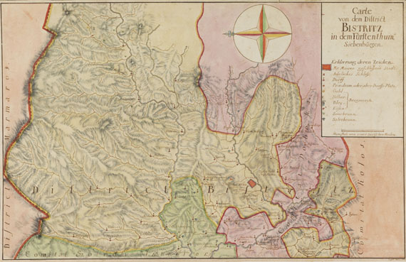
Die Aquarellzeichnung (30,5 : 47 cm, ) zeigt eine "Carte von dem District Bistritz in dem Fürstenthum Siebenbürgen" (signiert "Lutsch 1752)"; ferner enthalten zwei Kupferstiche mit Randansichten (Kronstadt, Segesvar, Deva, Fogaras, Peterwardein u. a.) zu einer großen, mehrblättrigen Karte von Rumänien Mappa della Transilvania e Provintie von Giovanni Morando Visconti (Hermannsstadt 1699), eine Teilkarte von der Slowakei Comitatus Posoniensis Germanis Presburg (Homann Erben 1757), eine Karte von Kroatien mit den künstlichen Schiffahrtswegen und Flüssen, die eine "Ausfuhr aus dem Koenigreiche Ungarn zum Adriatischen Meere erleichtern und befoerdern will" (Wien, Franz Xaver Müller um 1800), sowie eine Karte von Savoyen und Lombardei (Homann Erben 1749), u. a. - 1 Beigabe.
- ZUSTAND: Ränder etwas (stock-)fleckig.
Collection of 10 maps. Copper engravings (8, some colored), 1 outline colored lithograph and 1 watercolor drawing. Mainly Germany and Austria. With partial maps of Transylvania, Croatia and Slovakia. From around 1690 to 1800. - Margins slightly (fox-) stained.
Sammlung von 10 Landkarten. Kupferstiche (8, tlw. koloriert), 1 grenzkolorierte Lithographie und 1 Aquarellzeichnung. Überwiegend Deutschland, Österreich. Um 1690 bis 1800. Bis ca. 55 : 96 cm.
Mit Teilkarten von Siebenbürgen, Kroatien und Slowakei, ferner Italien und Österreich.
Die Aquarellzeichnung (30,5 : 47 cm, ) zeigt eine "Carte von dem District Bistritz in dem Fürstenthum Siebenbürgen" (signiert "Lutsch 1752)"; ferner enthalten zwei Kupferstiche mit Randansichten (Kronstadt, Segesvar, Deva, Fogaras, Peterwardein u. a.) zu einer großen, mehrblättrigen Karte von Rumänien Mappa della Transilvania e Provintie von Giovanni Morando Visconti (Hermannsstadt 1699), eine Teilkarte von der Slowakei Comitatus Posoniensis Germanis Presburg (Homann Erben 1757), eine Karte von Kroatien mit den künstlichen Schiffahrtswegen und Flüssen, die eine "Ausfuhr aus dem Koenigreiche Ungarn zum Adriatischen Meere erleichtern und befoerdern will" (Wien, Franz Xaver Müller um 1800), sowie eine Karte von Savoyen und Lombardei (Homann Erben 1749), u. a. - 1 Beigabe.
- ZUSTAND: Ränder etwas (stock-)fleckig.
Collection of 10 maps. Copper engravings (8, some colored), 1 outline colored lithograph and 1 watercolor drawing. Mainly Germany and Austria. With partial maps of Transylvania, Croatia and Slovakia. From around 1690 to 1800. - Margins slightly (fox-) stained.
Ulteriori informazioni
452
Visconti, Giovanni Morendo
11 Landkarten von Osteuropa, um 1690-1800.
Stima:
€ 1,000 / $ 1,070 Risultato:
€ 2,706 / $ 2,895 ( commissione inclusa)
Ulteriori informazioni